

633 words, 3 minutes read time.
CC BY 2.0
Photo By Victor R. Ruiz
https://www.flickr.com/photos/rvr/22602366007/
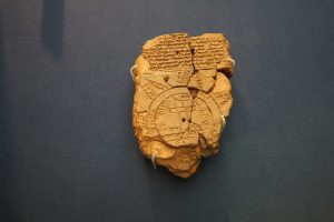
In the heart of The British Museum, amidst towering statues and intricate artifacts, lies a seemingly modest clay tablet that has captivated scholars and enthusiasts alike. This unassuming object, known as the Babylonian Map of the World, offers a window into the ancient worldview of the Babylonians, revealing much more than just geographical knowledge. It intertwines with biblical narratives and offers fascinating insights into ancient Mesopotamian beliefs and cosmology.
The Babylonian Map of the World, dating back to the 6th century BCE, is a remarkable artifact not only for its historical value but also for its connection to biblical stories. At first glance, this clay tablet, though damaged, presents a compelling representation of how the Babylonians perceived their world. The map is inscribed with cuneiform script, an ancient writing system used in Mesopotamia, and it features a unique depiction of the known world surrounded by a “Bitter River” – a concept that was central to their cosmological views.
What makes this map particularly intriguing is its depiction of the world as seen by the Babylonians. At the center of the map lies Mesopotamia, which corresponds to modern-day Iraq, with the Euphrates River running through it. Babylon, a city of immense historical significance, is prominently marked. This central focus on Babylon and the surrounding rivers reflects the importance of these geographical features to the Babylonians, not just for their daily life but also in their understanding of the universe.
Beyond the central circle, the map extends to include regions that the Babylonians believed were beyond the known world. These outer regions are represented by pointed triangles or “mountains,” which were thought to be magical or mysterious lands. The Babylonians imbued these areas with mythological significance, reflecting their belief in a world filled with wonder and the supernatural.
One of the most compelling aspects of the map is its connection to the biblical story of Noah’s Ark. According to Irving Finkel, a curator at The British Museum, one of the triangles on the map corresponds to a description of a great wall, which can be linked to the biblical Ark. The map’s depiction of a place where the Ark was said to rest on a mountain parallels the biblical account of Noah’s Ark landing on Mount Ararat. This connection is made even more profound by the fact that the Babylonian term “Urartu” appears on the map, which is related to the Hebrew “Ararat.”
The discovery of a missing fragment of the map by Edith Horsley, a cuneiform enthusiast, added a crucial piece to the puzzle. This fragment, which fit perfectly into a gap on the map, allowed scholars to match the descriptions on the map with the actual geographical features it depicted. This find was a significant breakthrough, as it provided clarity on the map’s portrayal of distant lands and reinforced the link between Babylonian cosmology and biblical narratives.
From a Christian perspective, the Babylonian Map of the World offers an intriguing look at how ancient cultures perceived their place in the universe and their connection to biblical stories. It serves as a reminder of the rich interplay between history, geography, and faith. The map not only illustrates the Babylonians’ understanding of their world but also highlights the shared themes and stories that transcend cultures and time periods.
In conclusion, the Babylonian Map of the World is much more than a historical artifact. It is a testament to the Babylonians’ complex worldview and their integration of mythology and geography. For Christians and historians alike, it provides a valuable context for understanding the intersection of ancient beliefs with biblical accounts. As we delve into the mysteries of ancient maps and artifacts, we gain a deeper appreciation for the ways in which our ancestors sought to make sense of their world and their place within it.